


Local Sponsors
-
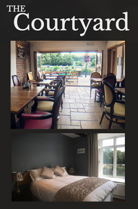
The Courtyard
3/4 Severn Side South, Bewdley, DY12 2DX.
Refreshing Drink Craft gins, cocktails and local ales The Courtyard, based in the heart of Bewdley, is here to welcome you with delectable dishes, refreshing drinks and a comfy, cosy night in one of our luxury rooms. Enjoy the scenery of panoramic views of the famous River Severn as well as the idyllic village of Bewdley from our bi-folding doors whilst you enjoy one of our exquisite meals. Here at The Courtyard we specialise in freshly grilled food; from a range of mouth-watering steaks to our highly sought-after fish and seafood specials, we have a menu that appeals to everybody with a contemporary twist. As well as enjoying our vast range of dishes, we offer a range of refreshing drinks at our bar including craft gins, cocktails and local ales.
-
The Severn Rivers Trust
Unit 3, Hope House Farm Barns, Hope House Lane, Martley. WR6 6QF
An independent environmental charity established to secure the preservation, protection, development and improvement of the rivers, streams, watercourses and water bodies in the Severn catchment.
-
Wales and South West
Canal and River Trust. Llanthony Warehouse, The Docks, Gloucester. GL1 2EH
The Canal and River Trust's historic canals and rivers provide a local haven for people and nature. We're the new charity entrusted with the care of 2,000 miles of waterways in England and Wales.
-
Unlocking the Severn - Canal and River Trust
Diglis Island, Diglis Dock Road, Worcester, WR5 3BS
Unlocking the Severn is a once-in-a-lifetime conservation and river-engagement project. Restoring connectivity on the River Severn will bring major benefits to its wildlife.Restoring 158 miles of river for shad. The project is inspired by one of the UK’s rarest fish. Hundreds of thousands of twaite shad used to migrate up the River Severn to reach their natural spawning grounds. But weirs installed in the mid-19th century blocked this annual migration. Unlocking the Severn will provide fish passage at six barriers on the River Severn and its River Teme tributary. This will restore 158 miles of river habitat and benefit a host of other important fish species including salmon and eel. The Canal and River Trust (lead), Severn Rivers Trust, Environment Agency and Natural England are the partner organizations for delivering this project. Unlocking the Severn is funded by the Heritage Lottery Fund and the EU LIFE Programme, as well as The Waterloo Foundation and the partners.
-
Num Lock Solutions (Bewdley)
32 Load Street, Bewdley, DY12 2AS
IT Support for home users and businesses in Bewdley, Worcestershire. We are specialists in IT support and repair services, providing our services to home users and small to large businesses across the West Midlands, since 1999. We also repair Mobile Phones and Tablets, including Apple and Samsung products. We offer free diagnosis and quotes on all repairs, as-well-as operating a “no fix no fee” policy. All repairs, unless otherwise specified, are booked in and diagnostics performed within a 48-hour period, we will then provide a quote for the repair and it is your choice if you wish for us to proceed. We strive to give you an affordable solution to your needs, possibly offering multiple options to allow you to decide the solution that best suits you. Our staff are very knowledgeable, friendly and approachable. Give us a call to discuss your needs and see how we can assist you.