
Local Sponsors
-
Nature's Design Studio
4 Market Street Tenbury Wells WR15 8BQ
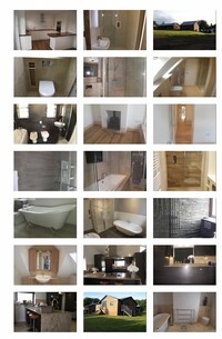
The showroom is located in the ancient market town of Tenbury Wells. The town is also known for its mineral water wells discovered in 1840. The mineral waters brought up in now restored Tenbury Spa, or Pump Rooms as it is generally known. Surrounded by beautiful open countryside - it is also well known for it hops and cider apples. We design, supply and install Kitchens from the handmade to the budget granite work tops to laminate tops A Kitchen is the heart of every house and our needs can vary - It is important that time is taken to make this room the one to meet all your requirements. Bathrooms ... We design supply and install all types of bathrooms from Contemporary to Traditional styles Specialising in Stone wet room bathrooms with priority put your preferences and budget. Floors Specialising in Natural Stone such as Limestone, Travertine, Marble, Granite, Slate, Terracotta in all shapes and sizes. We can not only supply but have our own in house team that are experts in installing these kind of floors. We also supply Porcelain, Victorian, Quarry Tiles, Wood and Karndean for floors and we have a large selection of hand made ceramics, Glass tiles, Mosaic and Wall tiles.
-
G E Bright Electrical Ltd
5 Teme Street, Tenbury Wells, Worcestershire. WR15 8BB WR15 8BB
G E Bright Electrical Ltd is a family business established in 1952. We are based in Tenbury Wells, Worcestershire and provide electrical contracting services throughout Worcestershire, Shropshire and Herefordshire. We are NICEIC, Part P, Trustmark and Construction line accredited electrical contractors working to British Standards 7671. We offer free quotations for Domestic, Commercial and Industrial Electrics. We specialise in Testing and Inspection, including PATS, for property sales and rentals, village halls, churches and all types of public buildings. We have electricians working in Tenbury Wells, Ludlow, Shrewsbury, Leominster, Bromyard, Hereford, Kington, Presteigne, Bewdley, Kidderminster, Stourport, Worcester, Droitwich, Bromsgrove and all surrounding areas.
-
The Severn Rivers Trust
Unit 3, Hope House Farm Barns, Hope House Lane, Martley. WR6 6QF
An independent environmental charity established to secure the preservation, protection, development and improvement of the rivers, streams, watercourses and water bodies in the Severn catchment.