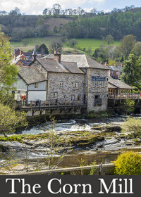
Many thanks to
The Corn Mill for facilitating this camera's location and capitally funding its installation.The River Dee originates from the slopes of Dduallt above Llanuwchllyn in the Snowdonia mountains of Merioneth, Gwynedd, Wales. It flows through Bala Lake and generally follows an east-south-east course as it descends from the Ordovician Denbigh Moors. Along its path, it passes over the man-made Horseshoe Falls and skirts the outcropping Karstic limestone formations north of Llangollen. Salmon can be caught in various sections of the river, from its tributaries in Bala Lake to as low as Farndon on the Cheshire plain, depending on the time of year. The lower beats in the Overton-on-Dee area are known for yielding the highest number of spring fish, while the middle and upper river around Llangollen and Corwen produce the majority of summer grilse and autumn fish.The River Dee flows through both Wales and England, serving as a border between the two countries. Originating in Snowdonia, Wales, it flows eastward, passing through Chester, England, before reaching the sea in an estuary located between Wales and the Wirral Peninsula in England. The river spans a total length of 70 miles. For centuries, the River Dee served as the traditional boundary of the Kingdom of Gwynedd in Wales, possibly since its establishment in the 5th century. It was documented in the 13th century as "flumen Dubr Duiu," with its name thought to derive from the Brythonic term dēvā, meaning "River of the Goddess" or "Holy River." The river is personified as the war and fate goddess Aerfen. Its name also influenced the naming of the Roman fortress Deva Victrix. The River Dee is the only river in the UK that is designated as a Water Protection Zone along its entire length down to Chester weir. The catchment area of the River Dee, encompassing the stretch down to Chester Weir, covers approximately 701.5 square miles. The estimated average annual rainfall in this catchment area is 25 inches, resulting in an average flow of 37 m3/s. While a significant portion of the catchment area is dedicated to agriculture and there are some abstractions from the river for summer irrigation, the volumes involved are not substantial.
Downstream from Chirk, the river valley has supported a range of industries that were initially attracted to the area by coal mines and later by the abundant deposits of Carboniferous clays used for brick and tile production. Previously, the wings for the Airbus A380 were transported by barge downriver to the Port of Mostyn from Airbus's manufacturing factory in Broughton, as they were too large for transportation via the Airbus Beluga. However, the dredging of the river for the barge may have contributed to a weakening of the tidal bore. Farson Digital has installed a webcam in Llangollen to monitor river levels and conditions, providing valuable information for fishermen, kayakers, and canoeists.