
Local Sponsors
-
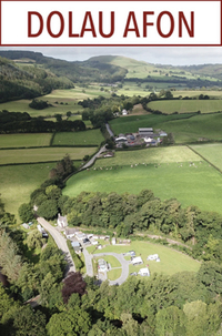
Dolau Afon Holidays
Dolau Afon, Llanafan, Aberystwyth, SY23 4BQ
Situated within the Cambrian Mountains, the last wilderness of Wales. Set within an 'International Dark Sky Area' and close to the west coast.Dolau Afon, a former 3 acre smallholding, which dates back some 200 years, and originally formed part of the Trawsgoed Estate. We are a small, friendly, husband and wife run/owned site, offering a rural retreat in spectacular and beautiful surroundings - peace, quiet and tranquility is what we are about. Some of the many beautiful things about staying with us, is the bird song, the lovely morning sunrise coming up the valley and the sun setting down the valley, the wonderful walks that surround us, the site being sheltered and south facing and the river, where you can take a dip in the pool under the bridge. Just a few reasons for coming to stay. Stay in our lovely self catering accommodation or camp on our beautiful touring campsite, surrounded by woodland, forest and bounded by the river Ystwyth. We welcome families, solo visitors, cyclists and motorcyclists, and we are dog friendly. From our site, there are a many opportunities for exploration and adventure, from walking, cycling or touring and star gazing. You might want to take advantage of our complimentary fishing licence, to fish from our riverbank, fly and spinning, worm only.
-
Aberystwyth University
Aberystwyth, Ceredigion. SY23 3FL
Since 1872, we have built a global reputation for teaching excellence and ground-breaking research. Today, we are home to students from all over the world. We pride ourselves on our welcome and inclusivity, while at the same time being a university rooted in excellence and research. As the first University College in Wales, Aberystwyth has a long and distinguished tradition of teaching and research, and our establishment in the 19th century is one of the great stories of pioneering achievement in modern Welsh history. Research and innovation are the lifeblood of Aberystwyth University. They deepen our knowledge and understanding, inform our teaching and enhance your learning experience, and deliver real benefits to everyday lives in Wales and the wider world. For Aberystwyth University, research really matters.