
Local Sponsors
-
Pengeulan at Sykes Cottages Ltd
Dovey Terrrace, Cemmaes. SY20 9PP
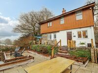
Nestled amongst the rolling countryside of Mid-Wales, in the quaint village of Cemmaes, rests this quirky detached holiday home, Pengeulan. Boasting a whitewashed, stone-built and wood-clad exterior whilst framing unspoilt views across the tranquil waters of the River Dyfi, Pengeulan makes an idyllic base for a family staycation to Wales. Follow the footpath alongside the charming terraced properties and make your way through the gated entrance and into your private garden; a truly lovely spot to soak in the rural setting of your new home-from-home.Stepping inside, be charmed by the industrial décor of the well-equipped kitchen, where you can look forward to a romantic meal for two at the snug breakfast bar, or venture upstairs to indulge with your loved ones in the open-plan living/dining room. In the summer months, make mealtimes an alfresco affair with a sociable seat on the patio, where you can enjoy a crisp glass of wine as you watch the charming wildlife graze in the green fields nearby, or head back indoors and settle down for the evening with a sumptuous spot in front of the television, gently warming your toes with the glow of the rustic woodburning stove. On cloudless nights, sit out side on the adirondack chairs, kick back and enjoy the Official Dark Skies, observing the Milky Way and other constellations before retiring to either of two well-presented bedrooms to catch your rest, with the choice between a double and a twin, with the latter offering the perfect space for little ones. A short walk from your doorstep will bring you into the heart of the local village of Cemmaes, where you'll find a number of helpful amenities to assist with your self-catering needs, including a traditional country pub and a well-stocked convenience store, perfect for picking up any last minute essentials.Get better acquainted with your surroundings and take a scenic stroll along the banks of the River Dyfi, providing a lovely spot to explore the rolling countryside of Mid Wales, or for a more thrilling experience, try your hand at clay pigeon shooting at Dovey Valley Shooting Ground. For a coastal adventure, head to the nearby university town of Aberystwyth, where you can immerse yourself in the area's fascinating history with a tour of Amgueddfa Ceredigion Museum, soak in the sights aboard the heritage Aberystwyth Cliff Railway, or spend lazy days paddling the shores at Aberystwyth Beach.